Groundwater Exploration and Assessment project Australia
Groundwater Exploration and Assessment project Australia

MCC-financed study finds Niger to be most groundwater-rich country in the Sahel region
RTI Exploration contributed to revolutionary groundwater discoveries in Southern Niger. March 22, 2023
More details

Dr Alain Gachet receiving the Légion d'Honneur
A short video in French for the Légion d'Honneur ceremony - 2015
More details

Mapping Water Potential: The Use of WATEX to Support UNHCR Refugee Camp Operations in Eastern Chad
An article about the use of the WATEX™ System to find groundwater for the Sudanese refugees in Chad - April 2006
More details

Combating drought in the Horn of Africa
The use of new remote sensing processing to map groundwater in the Horn of Africa, by RTI - January 2012
More details

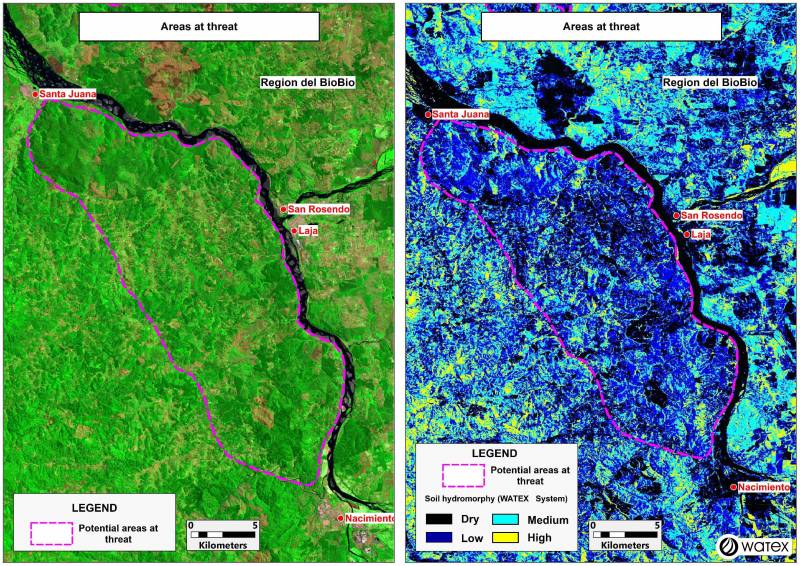
THE WATEX™ SYSTEM, A KEY TECHNOLOGY FOR FIRE PREVENTION IN CHILE
The WATEX™ Process mapping results indicate the location of areas exposed to forest fires in Bio Bio Region, Chile.
More details

Satellites guide aid workers sinking water wells for African refugees
The use of satellite imagery as key data to produce groundwater targets maps of Chad/Sudan areas - September 2004
More details
RTI EXPLORATION is a global leader in the exploration sciences. We provide clients with the expertise and technology they need to discover and develop critical resources, from minerals and metals to groundwater and energy resources. Our team of highly experienced professionals has a proven track record of success in locating and developing some of the world's most important resources. Areas of expertise:
Our technologies can be adopted independently or combined together into an integrated solution, ready for execution project development master plan:
- WATEX™ : Precise Delineation of Groundwater Reservoirs down to 3 Km
- BAMEX™ : Uncovering the Optimal Mineral Potential to be Unlocked
- HEXUB™ : Accurate Delineation of Areas of Major Hydrocarbon Interest
- OSIRIS™ : Environmental Monitoring, Soil and Forest Classifications
Our services in the sector of
Australia
Contact Us


